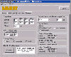
The Mission Planner is the common planning
platform for the Sherpa range of Guided Parachute Delivery Systems.
It feature as intuitive windows based, graphic user interface. From
the data entered it will calculate optimal, earliest and latest
dispatch points and allow "what-if" planning and editing of all data.
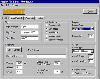
It is also used to download flight
Once the data
is entered the waypoints and dispatch point are displayed
graphically. Waypoints may be edited and dispatch zones viewed
graphically at different altitudes using a slide bar.
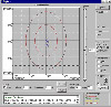
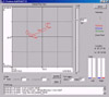
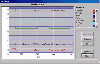
After completion of a mission, recorded data
from the Sherpa Guidance Unit may be downloaded into the Mission Planner
and displayed in a plan view as shown. A vertical slide bar is used to
change the elapsed time.